VISITORS IN BEARS EARS: How We Can Make a Stronger Case for the National Monument
Text: Andreea Lotak; Photos: Justin & Andreea Lotak · 12 min read
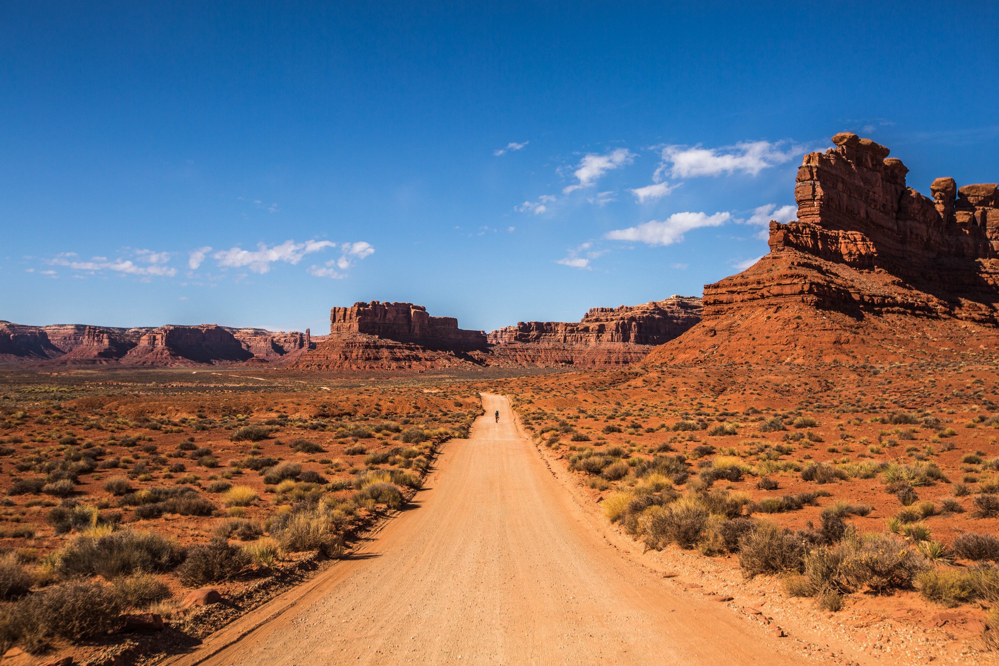
Walking among impressive rock formations in the Valley of Gods, along the 17-mile drive loop
The day the President announced that Bears Ears could lose 85% of its original boundaries, we wrote this on our social media: “The boundaries of Bears Ears have been traced in many people’s hearts and minds and will remain there. Regardless of where the political process places these boundaries, the idea of Bears Ears will not be erased. Even if in this cycle steps were taken backwards, it is as Victor Hugo noticed: nothing can stop an idea whose time has come. It’s time to honor tribes and learn from their vision. Keep heading to Bears Ears in respect and awe, explore all the places carved out of the monument, walk through it, treat it as if nothing has changed. All these boundaries are imaginary for nature, but are needed for us humans to know where to stop our greed. As travelers returning to this region, we can help those locals who opposed the monument to see, in time, that their communities can be revived economically because of this land called Bears Ears.” But as visitors we can also have the reverse impact if we head into this landscape unprepared.
edited April 3, 2018: the article below was published following the Presidential Proclamation of December 4, 2017 which took out 85% of the land from Bears Ears and split it into two smaller monuments. Now the Bureau of Land Management is asking for public comments until April 11. You can submit yours here if you wish to support Bears Ears remain as it was while the legal battle continues in court.
In an article from National Geographic, Josh Ewing, from Friends of Cedar Mesa, expressed the concern that the most immediate threat to Bears Ears now is visitation. During our road trip to twenty national monuments, we learned that many of them are underfunded and understaffed. A BLM volunteer told us that there are many ways to kill a national monument, and not having enough workers and funds is one. Bears Ears has remained seriously understaffed, in a large area where tens of thousands of Native artifacts are scattered. Then there’s the fact that Bears Ears is rugged country, where you can easily find yourself isolated and disconnected from everyone. This is part of its beauty, but it can also mean trouble.
When we stopped by the Visitors Center in Blanding, UT, one of the gateways to the young national monument, the volunteer working there told us about the many headaches that the county sheriff has had in 2017 since Bears Ears made headlines. He told us that San Juan county saw a 40% increase in visitation already that year, but that many people coming expect to see an actual ‘monument’, something clearly delimitated, and to have an experience similar to that of being in a national park. While the iconic buttes that gave the name of the national monument are a visible landmark from the Scenic Byway 95, the 1.35 million acres are much more than that and require some skills to safely navigate. Friends of Cedar Mesa have helped create a map of the monument, which is also available at most visitor centers in the region. We strongly recommend picking one up when traveling through the monument. Even with a map however, the archaeological sites are easy to miss and aren’t particularly signaled. The reason is to keep away large flocks of visitors and to protect resources so long as the monument remains understaffed and underfunded. The roads in the monument are mostly unpaved and crisscross through a truly wild landscape. It was the only national monument where we woke up to a flat tire. It’s the reason why some people in Blanding opposing the monument have been complaining that it’s become a habit now to have visitors stranded out there, calling for help from local authorities. Whether this really happens often or it’s an exaggeration to make a point, there are ways to avoid it. Never travel with heavy rain on these remote roads, have extra supplies and definitely at least one spare tire, preferably with a tire repair kit. If visiting in the middle of summer, bring as much water and food as you can. Bears Ears is mostly a true wilderness, even though it does not have that official designation.
If visiting responsibly and respectfully, travelers to Bears Ears can help change the fate of conservation in this region. The economic benefits tourism brings can make a strong case for preserving this area, in the context of heavy involvement and lobbying from extractive industries. The stakes are high. It is now known that a uranium company was heavily involved in the national monument’s review, and that oil and coal played a much more important rolethan initially disclosed in the dramatic reduction in size of Bears Ears. With the monument status weakened and important areas taken out, there are thousands of sites and artifacts out on this landscape that are no longer under any protection, which exposes them to vandalism and looting. These have been recurrent problems before the monument and one of the main reasons why the tribes fought for the conservation status of this land. As visitors, we can help mitigate our impacts, contribute to the local economy, help revive the communities which will eventually embrace the new opportunities, support tribal efforts to protect their sacred lands, and take the chance to truly learn and appreciate more about the history and culture of these places.
We drove up to Bears Ears from Grand Staircase-Escalante National Monument following this route: Scenic Byway 12 to State Rte 24 and to State Rte 95, passing through Capitol Reef National Park. We entered the surreal lands at the southwestern end of Bears Ears at sunset. This remains one of the most spectacular scenic drives we’ve ever done. The red and pink light softly brightened the Jacob’s Seat and the Cheese Box rock formations. Soon after, we reached the tree-covered mountains of the Manti-La Sal National Forest from where the Bears Ears buttes rose, like the head of a bear poking through the ground.
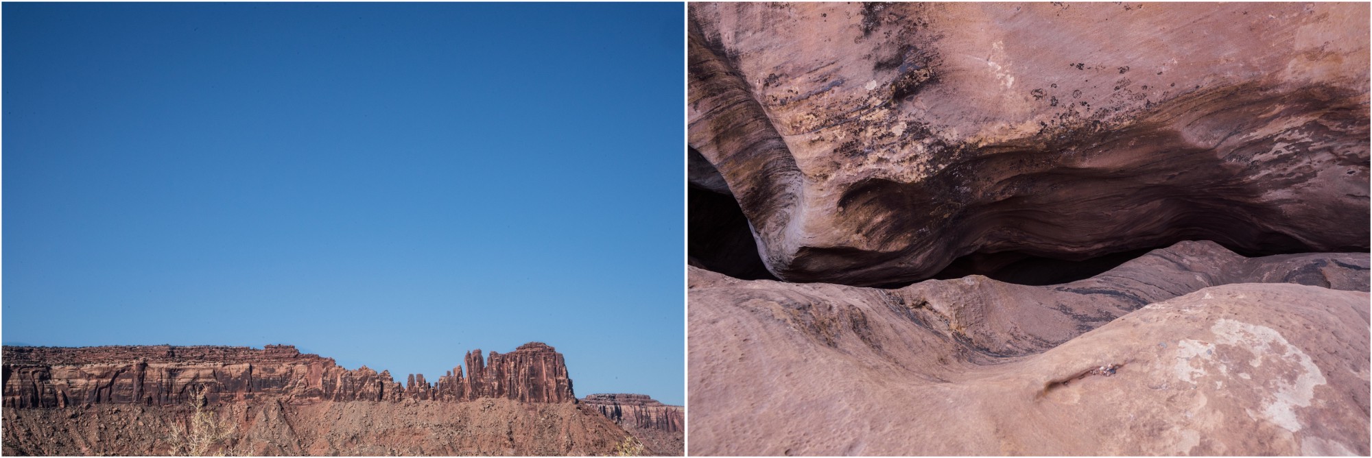
This scenic drive is paved, but the Elk Ridge Road Scenic Backway that can take you through the buttes and on to the other side of the ridge through a stunningly beautiful landscape is a rough forest road. These lands have been excluded from any protections under the president’s proclamation, and are marked to have medium to high potential for uranium mining. While winding along the unpaved roads with dizzying precipices on the side, the vistas that open up are breathtaking. We found ourselves surrounded by the tall Abajo Mountains, with aspen groves and pine forests, and by the incredibly beautiful canyons and rock formations that stretch into Canyonlands National Park. To the north, the Indian Creek and Lockhart Basin areas are places held dear by Native tribes, rock climbers, wildlife-watching enthusiasts and hikers.
Another scenic drive is that in the Valley of the Gods, 17-miles of gravel road winding through “fortresses” and rock “sculptures” shooting up to the sky. This red and orange landscape holds a sacred importance for the Navajo/Diné, and some of these rock formations are believed to be the spirits of ancient warriors. Exiting this area you can head up to the Cedar Mesa Plateau along the narrow and winding Moki Dug Road, which will give you an amazing view of the entire valley below. The beauty of this wild country is so outstanding that one can’t imagine any mining developments within it. We were told by someone who mostly opposed the monument that there are, in fact, historic uranium mines in this southern stretch of Bears Ears and that we wouldn’t be able to see them anyway; that it’s all an exaggeration and that mining wouldn’t strip away the beauty and health of the land. It’s hard to imagine though that a corporation with today’s technology would leave behind as small a trace as a family-owned mining operation from the early 20th century. The towns of Blanding and Monticello maintain a significant local opposition to the monument, but both look like they could benefit from more economic opportunities. Bluff, to the south, is a much smaller town that took a stance to support Bears Ears. It has nice cafes, some outfitters, lodges and motels, and has become a quaint place to spend the night and use as a base camp for exploring Bears Ears. Soon, Friends of Cedar Mesa will open an education center to help travelers visit the region respectfully and know where the best places to visit are located. Bluff is also one of the departure points for guided rafting trips along the San Juan River.
Beyond the politics and economics of Bears Ears, which led to so much dispute and a highly controversial monument review, this place represents a historic moment for five local tribes and for Native heritage everywhere. The Hopi Tribe, Navajo Nation, Ute Mountain Ute Tribe, Pueblo of Zuni and Ute Indian Tribe all formed an Inter-Tribal Coalition to see Bears Ears protected. Through the monument’s original proclamation, they were given a role in the management of the area, and their historic rights on these lands were guaranteed. It was the first time such an agreement had ever been reached. For all these tribes the national monument is home to the legacy of their ancestors and a living cultural space where they can go to practice their traditions. There are around 100,000 archaeological and cultural sites, sacred burial grounds, and historic hunting and gathering ranges. The Native history here goes from the last Ice Age all the way to Navajo leaders who helped their bands escape the forced relocation by the US Army in the 1800s. History continues to be made here, and the monument honored the legacy of the Mormon settlers, as well as the interest of today’s visitors in recreation opportunities.
As visitors, the best we can do is go out there informed and prepared. Remember that sometimes the safest and most fulfilling way to see a remote place is with the help of a local guide. Finally, to honor tribes and the cultural heritage in Bears Ears, as well as to help its conservation into the future, we can take a pledge for ourselves:
to respectfully see these places, to hold them dear for the heritage that they host, and to understand why they matter so much to the tribes that are fighting to keep them protected;
to recreate responsibly and do everything we can to leave as little of a trace as possible in a place that has almost no staff to tend to it;
to be open-minded to the fact that the infrastructure and the facilities available are limited, and know that it’s not because the place is not important, but because no funding is given due to the current political game;
to appreciate its beauty and importance despite any discomfort;
to support local businesses in the adjacent communities and maybe make a point in letting them know that we’re there because of Bears Ears.
Below you’ll find a selection of photographs that might inspire you to visit these beautiful places in Bear Ears’ country.

Approaching Bears Ears from the Glen Canyon National Recreation Area, along Rte 95. Lake Powell stretches below (right photo), while the road crosses the Colorado River on the Hite Bridge and the Dirty Devil River (left photo).

Left: The Bears Ears buttes in the distance. They are believed to be a shrine that protects the Navajo/Diné. Right: The heights of the mountains in the Manti-La Sal National Forest give way to pine forests and aspen groves.

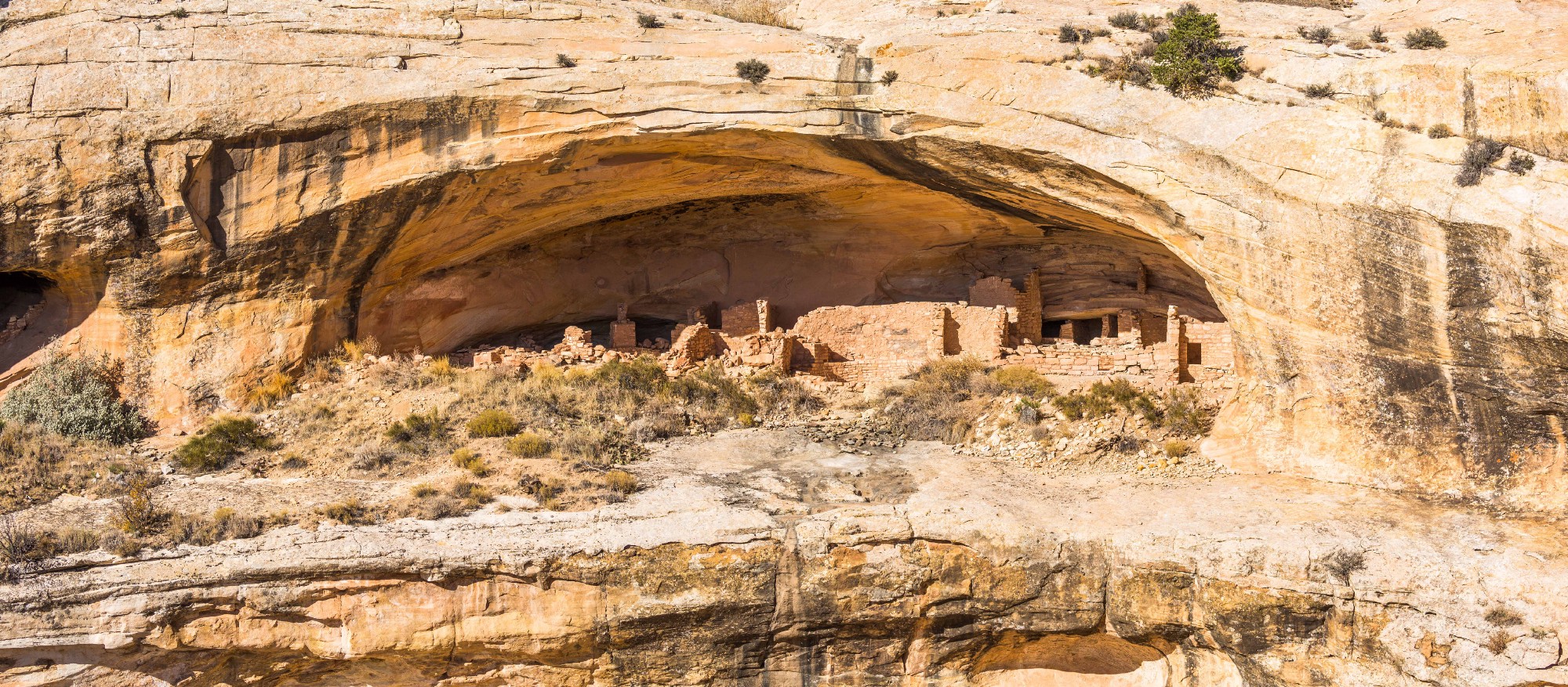
Above, left: Newspaper Rock is one of the most popular and easily accesible sites in Bear Ears. It’s an impressive rock wall recording 12,000 years of human history in the region. Above, right: Looking into one of the many ‘kivas’ that can be seen in the monument. No access is allowed inside these structures which played a ritual role in the Pueblo cultures. Bottom: The Butler Wash ruins where Friends of Cedar Mesa have installed information panels.

The Elk Ridge Road Scenic Backway takes visitors to some breathtaking parts of the monument and national forest.

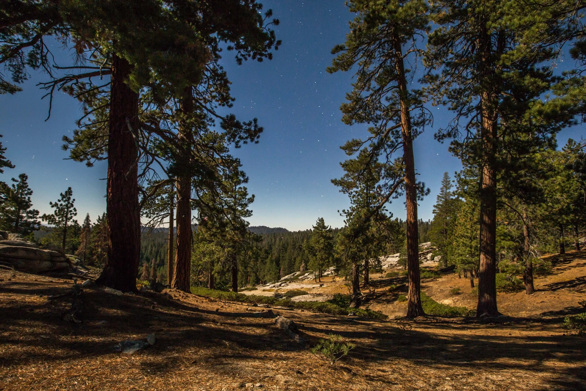
Left: Looking at the stunning canyons that stretch into the Canyonlands National Park. Right: Nighttime along the Elk Ridge Road.

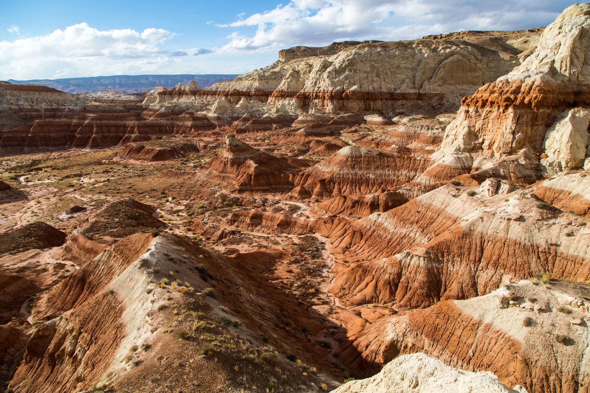
Cedar Mesa stone formation in the Valley of Gods
World class rock climbing and canyoneering are two of the activities that have put the monument on the map for many outdoor sports enthusiasts.

Sunset from behind the Bears Ears west butte in the Manti-La Sal National Forest.


Recommendations on visiting Bears Ears National Monument in Utah, with a selection of photographs to give you a glimpse into the beauty of these wild and historic lands.